Adapting to Changing Weather Patterns Through Smart Greenway Planning
Considering the changing climate, and specifically more extreme precipitation patterns, we need to rethink how to capture, direct, and dissipate water to best benefit our community and local ecology. The five and 100-year rain events of the past—used as parameters for designing urban drainage system capacities—no longer fit changing weather patterns. Intense downpours have become more frequent and erratic, dependent on the evolving patterns of slower and meandering jet streams that typically feed this region’s moisture from the warming oceans. Periods between rains have lengthened due to persistent high-pressure ridges along our coastline, resulting in drought. More intense precipitation events called atmospheric rivers, are becoming commonplace.
How do we mitigate and adapt to these evolving weather patterns? Regional planning concepts and strategies applied to storm water and drought management, site design and informed engineering could be readily applied in the development of the Southeast Greenway.
The first consideration is to understand the regional parameters around the Greenway: the extent of the watershed, the upstream (Spring Lake) and downstream (creeks flowing west) conditions and impacts. Next, we would look at adjacent conditions and the existing site, analyzing soils and topography to locate permeable and impermeable surfaces, existing drainage patterns, storm water utilities and so forth.
With this information in hand, it’s possible to weigh the merits of water management concepts – undoing past engineering practices which typically sped water down gutters and culverts to the nearest storm drain – and incorporate strategies which have proven successful in meeting changing conditions both locally and elsewhere.
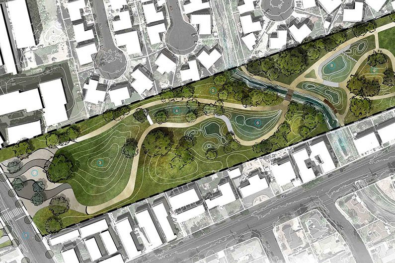
Student Project – Plan illustrating drainage capture and detention along the Greenway near Yulupa Avenue. Credit: Art Academy University, Dept. of Landscape Architecture, Nahal Sobati, topophyla.com
Imagine Spring Creek being daylighted and the topography along the Greenway being graded in a way to capture runoff from surrounding neighborhoods. A series of holding ponds and vernal pools could temporarily detain this water to filter out sediment, then release it to slow the flow downstream. Such a scheme could result in a multi-dimensional, biodiverse two-mile corridor that benefits the community, creates healthy habitat areas for wildlife and helps us adapt to climate change.
Sound familiar? Spring Lake was created in the 60’s to capture water from storm events and this park and watershed connects to the Greenway. Similar, though on a larger scale, look at how that project benefits Santa Rosa and the surrounding area!
Philip Frankl is a landscape architect, educator, and member of the Southeast Greenway Campaign Committee.